Day 22 |
Date |
Weather |
Total Plan Miles |
Actual Miles |
| Sun, Aug 17, 1997 |
Mostly Sunny
Showers
56-77 |
4839 |
4915 |
From
(Plan) |
From
(Actual) |
To
(Plan) |
To
(Actual) |
Today's Miles
(Plan) |
Today's Miles
(Act.) |
| Vernon,BC |
Vernon,BC |
Hope,BC |
Hope,BC |
170 |
185 |
 After another brief stop with
the Shillams along Lake Okanogan in Kelowna, we left the
Okanogan Valley. We were to meet our friends Jerry and Mary
Morris in Victoria the next day. From Vernon to Victoria is
well over 250 miles. Plus, there is a 2 hour ferry ride as
part of the trip. We chose to leave Vernon at about 4:00 and
put about 175 miles behind us. We planned to stay the night
in Hope, BC.
After another brief stop with
the Shillams along Lake Okanogan in Kelowna, we left the
Okanogan Valley. We were to meet our friends Jerry and Mary
Morris in Victoria the next day. From Vernon to Victoria is
well over 250 miles. Plus, there is a 2 hour ferry ride as
part of the trip. We chose to leave Vernon at about 4:00 and
put about 175 miles behind us. We planned to stay the night
in Hope, BC.
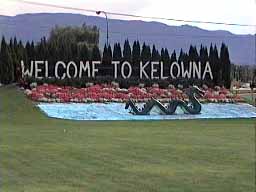
We took BC97 south, back (again) through Kelowna. On the
way into town, we found this nice welcome, complete with a
model of the famous Ogopogo. The legend of the Ogopogo is
similar to that of the Loch Ness monster in Scotland, except
they are unrelated. The indigenous people of the Okanogan
Valley told the white settlers about the large animal that
lived in the lake. They thought they had found its home cave
and frequently made offerings to it there in hopes of
keeping it appeased and friendly.
There are actually people living on the lake who report
having seen evidence of the beast: unexplained ripples on
the water, or a scaly back erupting above the surface of the
water, only to disappear again without a trace.
Is it real or just a well developed and executed myth
created by wily businessmen to increase tourism? I, like
them, will leave the answer to that question up to you.
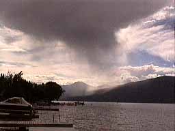 The Okanogan Valley treated us to some scattered
afternoon thundershowers as we left. South of Kelowna, we
picked up BC97C that connects the Okanogan with the
Coquihalla Toll Road that runs from Kamloops to Hope. BC97C
joins the Coquihalla (BC5) at a little valley town called
Merritt. It was Merritt were we should have stopped for
gasoline.
The Okanogan Valley treated us to some scattered
afternoon thundershowers as we left. South of Kelowna, we
picked up BC97C that connects the Okanogan with the
Coquihalla Toll Road that runs from Kamloops to Hope. BC97C
joins the Coquihalla (BC5) at a little valley town called
Merritt. It was Merritt were we should have stopped for
gasoline.
It is nearly 70 miles from Merritt to Hope, and we
expected to find frequent gas along a major and well
traveled route such as BC5. Certainly, the traveler would
expect to see a warning if gas would not be
available for such a long stretch. In our case, neither was the case.
Betsy went on her reserve tank a mile before we reached
the toll both at the top of Coquihalla Pass. We asked the
toll taker where the nearest gas could be found, and were
informed we'd have to wait until Hope. Hope was 36 miles
away. Betsy knew she could get 20 miles on reserve, but 36
was out of the question. The toll taker said, "Well, it's
mostly downhill, maybe you can get there on fumes..."
Thanks.
The road was steep , and I advised Betsy to pull in her
clutch and simply coast as much as she could. At least we
could reduce the distance we'd need to double back with a
gallon can of gas. As Betsy's trip odometer rolled past 20
miles, then 25 miles, the end of the gas supply seemed
imminent. At this point, even I had switched to my reserve
tank. At the 30 miles mark, the road dished out the worst
possible blow: it started an uphill grade! I knew we would
not make it, but we were so close we now had to decide
whether to park Betsy's bike and come back with gas, or just
push it into town.
Somehow, and I really don't know how, the bikes continued
to run all the way into Hope. We made it! We stopped for gas
at the first station we came to. Harley Davidson says Betsy
has a 4.25 gallon gas tank, but somehow, we were able to put
in 4.35 gallons! That tank was empty!
As we checked into what was (perhaps) the nicest hotel
room we've had on this trip, we laughed. We learned a deep,
valuable, and important lesson today: when you're out of
gas, and everything's going down hill, don't despair as
there's always Hope!
Updated 8/19/97 by
Robert Farrell
Email me |
|
 |